
We drove to the Alamo Road exit off the I-40 at Yucca. See the map. Then we backtracked on freeway frontage to the County 15. At this point, we were just following the guy in front of us on a long, dusty, but well-graded road. Hard to see the scenery, which was spectacular, because we were waiting for the dust to clear in front of us to glimpse the road and vehicle ahead. If you came to a fork in the road and the dust had cleared, you were kind of stuck, but we made it. We turned off County 15 just at the sign indicating from that point on the road wasn't maintained. Took a road to the right, which is pretty much 4-wheel drive the rest of the way to Signal Mine. We had one trouble after another and got very discouraged about these rock club field trips. Learned a little and will return to this area to look around by ourselves, but will only venture on to roads we know are safe for our little 2-wheel-sticks-in-the-sand-pickup truck. I was stressed, but Gaby had a great time.
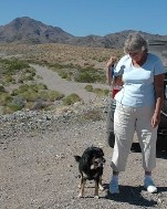
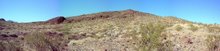
 View from near the entrance to Signal Mine
There was really no clue before hand where we were going or what we were looking for. I found out at the mine we were looking for Travertine and possibly some Barite crystals. Now I have been told it was something that looks like Travertine.
 Here's a topo map of the coordinates of McCracken Mine. I'm going to explore around some of the area's other topo maps.
We were nearly due east from Lake Havasu City. We had traveled southeast from Yucca. It turns out we were at Signal Mine. The topo map for the town of Signal is below.

For some history of the area, here's an online article by Roman Malach:
http://www.nuggetshooter.com/articles/Minewith2murders.html
He has also written a book called The Ghost of McCracken Mine. It should be available at the Museum in Bullhead City. Another place to explore.
http://www.bullheadcity.com/tourism/Hismuseum.asp
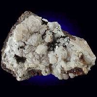
Travertine: (We weren't looking for Travertine, but for something that resembles it. But I'll post about it anyway. You never know.)
Here's an encyclopedia notation on Travertine. I stole it.
http://www.encyclopedia.com/html/t1/traverti.asp
travertine Related: Minerals
(trăv´ertĬn, -tēn) , form of massive calcium carbonate, CaCO 3 , resulting from deposition by springs or rivers. It is often beautifully colored and banded as a result of the presence of iron compounds or other (e.g., organic) impurities. This material is variously known as calc-sinter and calcareous tufa and (when used for decorative purposes) as onyx marble, Mexican onyx, and Egyptian or Oriental alabaster. Travertine is generally less coarse-grained and takes a higher polish than stalactite and stalagmite, which are similar in chemical composition and origin.
Here's a photo:

http://www.mii.org/Minerals/phototravertine.html
Now on to the other minerals that might be found in the area.
Here's a link to mindat.org. This is the listing for McCracken Mine and vicinity and the minerals that might be found there, with pictures! I'm going to steal a few photos to post and list the characteristics of each mineral. Even though this is an international site, there are photos for minerals in the USA. See the end. I am finding some photos of minerals collected nearby in California and Arizona. That's what I will post.
http://www.mindat.org/loc-39516.html
"Environment is a metamorphic complex of Precambrian age. Intrusive igneous rocks of Tertiary age. There is little alteration. Faulting is complex and of Tertiary volcanic rocks against Precambrian granitic rocks. Flows also overlie Precambrian rocks south of McCracken Peak. Jointing is perpendicular and parallel to the veins." This is an interesting place, geologically. It will be fun to return just to check that out.
Minerals listed: (I'll just post pictures from Arizona and California at least, if not from the McCracken Mine area. The exact location for each specimen is available at mindat.org)
Anglesite:


http://webmineral.com/data/Anglesite.shtml
Barite: (Yikes, 59 pages of photos of Barite. I'll have to pick three from Arizona.)


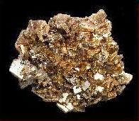
http://webmineral.com/data/Barite.shtml
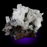
Calcite:
I'll post a couple of pictures here, but this is another group like the Barite Group. Look for a separate post. Yikes, I found 11 great specimens collected in just Arizona and California. Here's a couple, ok, three.

Cerussite:
Dolomite:
Fluorite:
Galena:
Hemimorphite:
Quartz:
Siderite:
I'll keep adding to this section.
I had heard about Alamo Lake, so I was thinking that County 15 continued on to the lake, but that way didn't look so promising. I did some research on the computer. Here's what I found.
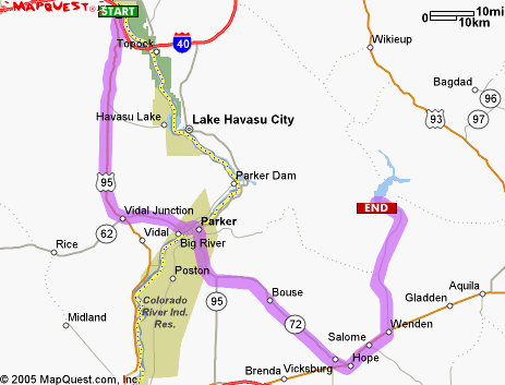 Here is the map for the improved road to Alamo Lake State Park.
Here's the website:
http://www.pr.state.az.us/Parks/parkhtml/alamo.html
Here's another link about Alamo Lake State Park:
http://www.americansouthwest.net/arizona/alamo_lake/state_park.html
Here's a link to the BLM site for the Aubrey Peak Wilderness:
http://www.blm.gov/az/rec/aubrey.htm
Here's the PDF file of a relief map of the Wilderness:
http://www.blm.gov/az/rec/maps/Aubrey.pdf
Here's a link about the Rawhide Mountains Wilderness:
http://www.blm.gov/az/rec/RAWHIDE.HTM
This whole trip has given us a lot to re-explore. I think what Gaby and I will do is proceed in ever-widening concentric circles from out homebase in Needles and go where we can. I keep looking over at the river terraces across the Colorado in Arizona. Maybe we will start at Topock and see what we find off of the road to Golden Shores. That will be fun. Definitely want to explore around Warm Springs Wash some more.
Later!


No comments:
Post a Comment